Ⅰ. 서론
예측(forecasting)이란 정책문제에 관한 사전정보를 기초로 하여 사회의 미래상태에 관한 실제적인 정보를 산출하는 절차로 투사, 예견, 추측 등 세 가지 형태가 있다. 투사(projection)란 과거로부터 현재까지의 추세를 기초하여 미래를 예측하는 방법이며 예견(prediction)은 명백한 이론적 가정들
Threats
- 중국이 해외건설에 있어 저가 입찰로 참여가 증가하고 있다.
- 세계 경제가 불안정하다.
- 신흥국가의 경제력이 우리나라를 위협하고 있다.
- 후발 개도국(중국, 인도, 터키등)업체들이 추격하고 있다.(중국의 경우에는 적극적인 국가적 지원에 힘입어 활발한 해외수주 활동을 벌이고 있
1. Location-Based Service Background
1.1. Definition of Location-Based Service
Location-Based services refer to general class of computer program-level services used to include specific controls for location and time data as control features in computer programs. Location-Based services utilize location information to improve business productivity as well as adding value to a comfortable life.
I. 서론
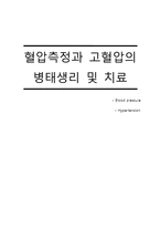
Blood Pressure
Figure 1-1 : 혈액이 혈관에 작용하는 혈압을 보여주고 있습니다.
혈관계 회로에서 심장박동의 펌프작용으로 박출된 혈액에 의해서 혈관벽(특히 동맥)에 생기는 압력. 심장에서 혈액이 박출될 때 약간 탄력성을 갖는 혈관벽이 조금 넓어지고 동시에 혈액은 혈관벽에 대한 혈
2.3.3 Process Explanation
1) Foolish Model
주어진 raw meterial에서 glucose를 얻는 당화공정과 이후 fermentation을 이용해 ethanol을 얻는 process로 실제의 공정보다 매우 단순화 되어있는 model. ethanol 생성공정을 거치면서 발생한 impurity는 이 모델에 포함된 centrifuge공정에 의해 분리되어 처리된다. foolish model의 output 으로
Map
Patent Map is analysis result that use MicroPatent company's patent analysis Tool “Aureka”, and there is meaning that whole technology takes a view of patent's distribution chart by (Keyword base) at a look. Height means high density extent (Number) of literature in contour line image and closeness of line displays relativity degree. Height means high density extent of literature in c
Service) Transit
: Information services to enhance the consumers’ travel experience with
SBS Transit (bus arrival time estimation)
The Transport & Travel e-Town
: one-stop integrated website providing government information and services
: local transportation and overseas travel for the general public
(from obtaining information to actually making reservations on your flight)
1) Features of Korean Geographical Information Service
Followings are the very controversies of Korean U-tour information services based on electronic map; very complicated road and address system, plenty of mountain terrain, large gap of geographic information between metropolitan and regional areas, national security issues(There are problems of satellite images that may be revealing nation
Product differentiation
Since the USGA limitation on dimension, volume, CT, and MOI, most golf club manufacturers were trying to achieve differentiation in drivers either lowering the center of gravity to increase launch angle or by offering clubs with adjustable features.
Nike Golf, Callaway Golf, Nickent Golf, and Nicklaus Golf had introduced drivers using square or other geometric shapes to